Store listing captured Apr 11, 2026 at 14:02
Media
Header


Extended metadata (JSON)
{
"android": {
"comments": [],
"available": true,
"priceText": "Free",
"scoreText": "3.9",
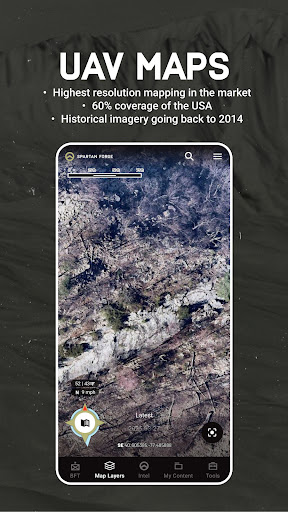
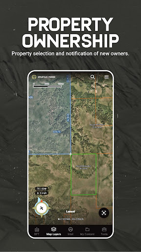
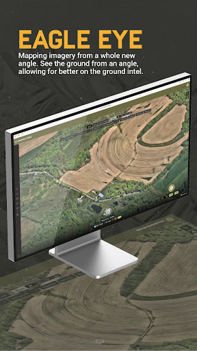
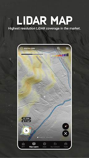
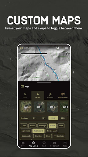
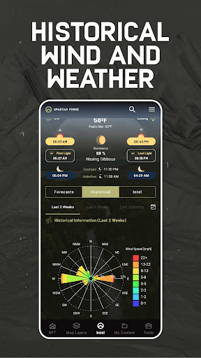
"descriptionHTML": "Navigate your next hunt with precision using Spartan Forge. Access advanced deer movement predictions, LiDAR maps, high-resolution satellite imagery, hunt units, and more—Built for hunters, by hunters.<br><br>Know where you stand with private and public land boundaries, ownership details, and stay informed when parcels change hands. Maximize your scouting and hunting strategy with high-resolution/historical UAV and historical satellite imagery (Sat-1), customizable LiDAR layers, and crop data overlays.<br><br>Plan your hunt ahead of time through extensive map customization, incorporating your choice of imagery, layers, and map overlays. A fully customized map is only a few taps away. Map presets support quick adaptation in the field, reducing time wasted staring at your screen. Mark crucial spots with pins, track distances to access points, and download offline maps to stay prepared no matter how far you roam.<br><br>Scout confidently with historical weather, wind patterns, and deer activity data. Use CyberScout, our expert-trained hunting AI, to answer your questions and help make smarter decisions while scouting or equipping gear. Share pins with hunting partners or coordinate in real-time using Blue Force Tracker.<br><br>Whether on your phone or desktop, Spartan Forge gives you the tools to find new ground, locate more game, and hunt smarter every season.<br><br>Key Features<br>• UAV Imagery and historical satellite layers with offline maps<br>Download offline satellite, topo, and hybrid maps. Access EagleEye imagery for side-angle views. Explore 5-15cm UAV imagery with historical data from 2016 and satellite imagery with 1-m resolution going back to 2017 (Sat-1).<br><br>• Fully Customizable LiDAR Maps<br>Unlock the landscape like never before with Spartan Forge’s LiDAR imagery. Available in both the app and desktop, our ultra-high-resolution LiDAR layer delivers the most detailed coverage in the industry. LiDAR reveals game trails, old logging roads, subtle terrain features, and even rock outcrops that other maps miss. Customize your LiDAR settings to highlight the most important features of your hunt and gain an unmatched edge in scouting, planning, and execution.<br><br>• Deer Prediction Neural Network<br>Harness the power of our advanced neural network, built on hundreds of GPS-collared deer and live data from all over the U.S., to predict deer movement and patterns with unmatched precision.<br><br>• Historical Wind & Weather Data<br>Access historical wind and weather patterns nationwide and log conditions using the journaling feature to build your insights library.<br><br>• Pin Sharing & Blue Force Tracker<br>Easily share pins by text or use Blue Force Tracker for bulk sharing across defined areas — perfect for team hunts and coordinated efforts.<br><br>• Private & Public Land Boundaries<br>View detailed landownership maps, mark access, and get notified when access changes — previously marked parcels turn purple, informing you when land has been sold.<br><br>• Crop Data Layers<br>Make informed decisions with crop layers that reveal crop type and year.<br><br>• CyberScout AI Assistant<br>Tap into CyberScout, a powerful hunting-specific AI trained to provide expert insights and guidance.<br><br>• Multi-Device Sync<br>Plan at home on your desktop, then take it into the field — seamlessly syncing across devices.<br><br>Membership Options<br><br>► Free Version<br>Get started with Spartan Forge for free. Access default maps, weather data, basic property ownership, and the ability to drop and manage pins — all the essentials to start planning your hunt.<br><br>► Paid Membership — One Price, All States (Yearly or Monthly)<br>One affordable membership gives you access to all states and all features — including private and public land boundaries, advanced deer prediction, CyberScout AI, historical UAV and satellite imagery, Blue Force Tracker, offline maps, and more.<br><br>Terms of Use<br>https://spartanforge.ai/pages/terms-of-service<br><br>Feedback<br>Have a question or want to suggest new features? Contact us at [email protected].",
"androidMaxVersion": "VARY",
"androidVersionText": "7.0",
"earlyAccessEnabled": false,
"developerInternalID": "Spartan+Forge+LLC",
"developerLegalEmail": "[email protected]",
"isAvailableInPlayPass": false,
"developerLegalPhoneNumber": "+1 571-308-8285"
}
}Categories (JSON)
[
  {
    "id": "SPORTS",
    "name": "Sports"
  }
]
Raw scraper payload (JSON)
{
"url": "https://play.google.com/store/apps/details?id=com.voidsoftware.outfitter&hl=en&gl=us",
"free": true,
"icon": "https://play-lh.googleusercontent.com/bt2xpnkA4XhDZtQlOl3IbCgHmJ32AThGeqkM71lzo75Au-wDXQBi3pt3aqojwP9Evk8",
"appId": "com.voidsoftware.outfitter",
"genre": "Sports",
"price": 0,
"score": 3.93,
"title": "Spartan Forge: Hunt",
"genreId": "SPORTS",
"ratings": 270,
"reviews": 189,
"summary": "All-in-one AI driven platform for planning and executing your hunt.",
"updated": 1773795952000,
"version": "1.17.50",
"IAPRange": "$7.99 - $79.99 per item",
"comments": [],
"currency": "USD",
"installs": "50,000+",
"released": "Sep 16, 2021",
"available": true,
"developer": "Spartan Forge LLC",
"histogram": {
"1": 48,
"2": 21,
"3": 5,
"4": 18,
"5": 175
},
"offersIAP": true,
"priceText": "Free",
"scoreText": "3.9",
"categories": [
{
"id": "SPORTS",
"name": "Sports"
}
],
"adSupported": false,
"description": "Navigate your next hunt with precision using Spartan Forge. Access advanced deer movement predictions, LiDAR maps, high-resolution satellite imagery, hunt units, and more—Built for hunters, by hunters.\n\nKnow where you stand with private and public land boundaries, ownership details, and stay informed when parcels change hands. Maximize your scouting and hunting strategy with high-resolution/historical UAV and historical satellite imagery (Sat-1), customizable LiDAR layers, and crop data overlays.\n\nPlan your hunt ahead of time through extensive map customization, incorporating your choice of imagery, layers, and map overlays. A fully customized map is only a few taps away. Map presets support quick adaptation in the field, reducing time wasted staring at your screen. Mark crucial spots with pins, track distances to access points, and download offline maps to stay prepared no matter how far you roam.\n\nScout confidently with historical weather, wind patterns, and deer activity data. Use CyberScout, our expert-trained hunting AI, to answer your questions and help make smarter decisions while scouting or equipping gear. Share pins with hunting partners or coordinate in real-time using Blue Force Tracker.\n\nWhether on your phone or desktop, Spartan Forge gives you the tools to find new ground, locate more game, and hunt smarter every season.\n\nKey Features\n• UAV Imagery and historical satellite layers with offline maps\nDownload offline satellite, topo, and hybrid maps. Access EagleEye imagery for side-angle views. Explore 5-15cm UAV imagery with historical data from 2016 and satellite imagery with 1-m resolution going back to 2017 (Sat-1).\n\n• Fully Customizable LiDAR Maps\nUnlock the landscape like never before with Spartan Forge’s LiDAR imagery. Available in both the app and desktop, our ultra-high-resolution LiDAR layer delivers the most detailed coverage in the industry. LiDAR reveals game trails, old logging roads, subtle terrain features, and even rock outcrops that other maps miss. Customize your LiDAR settings to highlight the most important features of your hunt and gain an unmatched edge in scouting, planning, and execution.\n\n• Deer Prediction Neural Network\nHarness the power of our advanced neural network, built on hundreds of GPS-collared deer and live data from all over the U.S., to predict deer movement and patterns with unmatched precision.\n\n• Historical Wind & Weather Data\nAccess historical wind and weather patterns nationwide and log conditions using the journaling feature to build your insights library.\n\n• Pin Sharing & Blue Force Tracker\nEasily share pins by text or use Blue Force Tracker for bulk sharing across defined areas — perfect for team hunts and coordinated efforts.\n\n• Private & Public Land Boundaries\nView detailed landownership maps, mark access, and get notified when access changes — previously marked parcels turn purple, informing you when land has been sold.\n\n• Crop Data Layers\nMake informed decisions with crop layers that reveal crop type and year.\n\n• CyberScout AI Assistant\nTap into CyberScout, a powerful hunting-specific AI trained to provide expert insights and guidance.\n\n• Multi-Device Sync\nPlan at home on your desktop, then take it into the field — seamlessly syncing across devices.\n\nMembership Options\n\n► Free Version\nGet started with Spartan Forge for free. Access default maps, weather data, basic property ownership, and the ability to drop and manage pins — all the essentials to start planning your hunt.\n\n► Paid Membership — One Price, All States (Yearly or Monthly)\nOne affordable membership gives you access to all states and all features — including private and public land boundaries, advanced deer prediction, CyberScout AI, historical UAV and satellite imagery, Blue Force Tracker, offline maps, and more.\n\nTerms of Use\nhttps://spartanforge.ai/pages/terms-of-service\n\nFeedback\nHave a question or want to suggest new features? Contact us at [email protected].",
"developerId": "Spartan+Forge+LLC",
"headerImage": "https://play-lh.googleusercontent.com/QGouqN2b26cRdfbTz4d7TrZ0LIzLt9qP8YVa_dCfDzirNuNX1Gpd0rcdRYwSMToVd9ZW",
"maxInstalls": 81347,
"minInstalls": 50000,
"preregister": false,
"screenshots": [
"https://play-lh.googleusercontent.com/h5ZaM8M_E_WWGUpO7lv8_4Y0zPB9ecoFP2YCggqP1PfnOZMOUtVDi9WXvyk2DpEoqlg",
"https://play-lh.googleusercontent.com/kZiidDL5pheVJQlKYtVTJjZ4IsME5eQclMRZUcsgYsuyO9LtPCrtIytWCzQenzpkWw",
"https://play-lh.googleusercontent.com/tvhos6E9_GvFy-dAuiYOIPOlJ7XWlUT-BpeLDJT5tHRWfU2Yw0aiFRt_GKDTMXm00YU",
"https://play-lh.googleusercontent.com/jMxPQSRiZRTm13z_CIZXz1VjUE16hq_euiTP1C1xCB3eDzB3mQOd9drHG35SIO56jg",
"https://play-lh.googleusercontent.com/4P0H8joUACtMPwAYN-qnsfeEKqXUFL66PZ5MCvofgOYs37iDJGU_ek6IFPzvvE7QDg",
"https://play-lh.googleusercontent.com/E-Eo65s7De9RaKg5f0HxHWS_2IPmAMyxDDgGkeCdRw0hhAiyY_YTbTcCOMFZhsx5vnKY",
"https://play-lh.googleusercontent.com/G1RIyXtiG-dorNywxK4jKfQWuKde6BOEQs9XxFDpfJUOuojLGZq4GHJnNbYVOP6qCQ",
"https://play-lh.googleusercontent.com/gEu5XbsYUAbXRpoZfEirq3EV29Ffw6j1jeAxY8Kfv2Hni26Sdm_QqfSzV6xL2jNNWwY",
"https://play-lh.googleusercontent.com/jV3t2WM4KOIYzX8ylhfV_XXufZ5hK-akv35zUhG8YKLWb-5LrFdZaEeUAjFsAKNBSg",
"https://play-lh.googleusercontent.com/sBiAM1HzLqEdwXrhF-s9SRGup4gamYOGyRTZDoar14yaL95jaVBZ7aVLEFPo0JJthyU",
"https://play-lh.googleusercontent.com/J7ysE7vDNRJZpNsffVQMxaxl37O4uL7B0KAmleCGd_cHhnJpeQYLm6f3m3zXTgttT4tp",
"https://play-lh.googleusercontent.com/SZewYbNIUKSTGN0pyk1f_GqkTFlvBxIFGJsh8_9oXYxjXSGo3Z1kEngi_mldexp4Pg",
"https://play-lh.googleusercontent.com/rPEakGipUgQlXZN7OQEMH5ztyi6gLhrn_LT2fPhgVN4kT4OYJcnqhwUAJkdN9Bv111g",
"https://play-lh.googleusercontent.com/QVsNE9uXc_ESCcbyNvUXEzrRD8Oh9ERgaj4J_9hOlE6M5jJ39rVQrL5WM9VaJf59tw",
"https://play-lh.googleusercontent.com/zeqBDqzy5UzWjZFY8uJ3OCudqWjtL2e4rVEIqQ80zhLga0hsHBFzSKh7A1LsWZIrEyI",
"https://play-lh.googleusercontent.com/JCBSVc_H-U1pJ9JKqfXLBdV_eTz2hEwMoE2aGqerbxgGecfGE0aDBXozmnfPWteOxtM",
"https://play-lh.googleusercontent.com/0eUIl72SmhXtEFuJVnUAb3vo-q-RPUhmIV_crqeqh5oh3wifWMeldbAcdGHI5HhoPtvL",
"https://play-lh.googleusercontent.com/3pSjGWbLzmXCsyrYTEKOD8-dgNjko47hrD2q0r9iDrgqYe8E-aY7CjmBPz_sD0cCqQ",
"https://play-lh.googleusercontent.com/6nU7zCMWVzDtcEHDCpGMjvGookYw5EDl7GSK_-EcLys8E6ZkylhJmByvMFsTkpkUiVc",
"https://play-lh.googleusercontent.com/bpmrwESEy45qGuD2NcN4kOFHWiOFQgQsf7WZZrCI0asHj8nDErbc6_WYZ_MPnibHFSQ0",
"https://play-lh.googleusercontent.com/drxCS7_cVyqZhvRlQi0Wt1ferxjAMn-G5XFdPR4Si1aM3Lx3JcuAbHnLNIuk_ZZwhd4",
"https://play-lh.googleusercontent.com/zS6qAj-b0e1pdivui8zpz8rgsRV7hzfdGokRm6Iwqx0562G_2yCAzeSBrIsQttxuPa4",
"https://play-lh.googleusercontent.com/-0ern7bem-ohFKBN2k5WmxOD5pKoXRG_xVCuzFpCViA-j7QRzL8wRL1FraOZyHWmLg",
"https://play-lh.googleusercontent.com/94csqr110SNbWAmo3hQ2q-ntMZJ5znR9wkJlTH1yxcsgtDIEIGXXDKrSKxAmIn3MCCk"
],
"contentRating": "Everyone",
"privacyPolicy": "https://www.spartanforge.ai/privacy-policy",
"recentChanges": "Application Stability and Updates",
"androidVersion": "7.0",
"developerEmail": "[email protected]",
"descriptionHTML": "Navigate your next hunt with precision using Spartan Forge. Access advanced deer movement predictions, LiDAR maps, high-resolution satellite imagery, hunt units, and more—Built for hunters, by hunters.<br><br>Know where you stand with private and public land boundaries, ownership details, and stay informed when parcels change hands. Maximize your scouting and hunting strategy with high-resolution/historical UAV and historical satellite imagery (Sat-1), customizable LiDAR layers, and crop data overlays.<br><br>Plan your hunt ahead of time through extensive map customization, incorporating your choice of imagery, layers, and map overlays. A fully customized map is only a few taps away. Map presets support quick adaptation in the field, reducing time wasted staring at your screen. Mark crucial spots with pins, track distances to access points, and download offline maps to stay prepared no matter how far you roam.<br><br>Scout confidently with historical weather, wind patterns, and deer activity data. Use CyberScout, our expert-trained hunting AI, to answer your questions and help make smarter decisions while scouting or equipping gear. Share pins with hunting partners or coordinate in real-time using Blue Force Tracker.<br><br>Whether on your phone or desktop, Spartan Forge gives you the tools to find new ground, locate more game, and hunt smarter every season.<br><br>Key Features<br>• UAV Imagery and historical satellite layers with offline maps<br>Download offline satellite, topo, and hybrid maps. Access EagleEye imagery for side-angle views. Explore 5-15cm UAV imagery with historical data from 2016 and satellite imagery with 1-m resolution going back to 2017 (Sat-1).<br><br>• Fully Customizable LiDAR Maps<br>Unlock the landscape like never before with Spartan Forge’s LiDAR imagery. Available in both the app and desktop, our ultra-high-resolution LiDAR layer delivers the most detailed coverage in the industry. LiDAR reveals game trails, old logging roads, subtle terrain features, and even rock outcrops that other maps miss. Customize your LiDAR settings to highlight the most important features of your hunt and gain an unmatched edge in scouting, planning, and execution.<br><br>• Deer Prediction Neural Network<br>Harness the power of our advanced neural network, built on hundreds of GPS-collared deer and live data from all over the U.S., to predict deer movement and patterns with unmatched precision.<br><br>• Historical Wind & Weather Data<br>Access historical wind and weather patterns nationwide and log conditions using the journaling feature to build your insights library.<br><br>• Pin Sharing & Blue Force Tracker<br>Easily share pins by text or use Blue Force Tracker for bulk sharing across defined areas — perfect for team hunts and coordinated efforts.<br><br>• Private & Public Land Boundaries<br>View detailed landownership maps, mark access, and get notified when access changes — previously marked parcels turn purple, informing you when land has been sold.<br><br>• Crop Data Layers<br>Make informed decisions with crop layers that reveal crop type and year.<br><br>• CyberScout AI Assistant<br>Tap into CyberScout, a powerful hunting-specific AI trained to provide expert insights and guidance.<br><br>• Multi-Device Sync<br>Plan at home on your desktop, then take it into the field — seamlessly syncing across devices.<br><br>Membership Options<br><br>► Free Version<br>Get started with Spartan Forge for free. Access default maps, weather data, basic property ownership, and the ability to drop and manage pins — all the essentials to start planning your hunt.<br><br>► Paid Membership — One Price, All States (Yearly or Monthly)<br>One affordable membership gives you access to all states and all features — including private and public land boundaries, advanced deer prediction, CyberScout AI, historical UAV and satellite imagery, Blue Force Tracker, offline maps, and more.<br><br>Terms of Use<br>https://spartanforge.ai/pages/terms-of-service<br><br>Feedback<br>Have a question or want to suggest new features? Contact us at [email protected].",
"developerWebsite": "https://www.spartanforge.ai",
"androidMaxVersion": "VARY",
"androidVersionText": "7.0",
"developerLegalName": "Spartan Forge LLC",
"earlyAccessEnabled": false,
"developerInternalID": "Spartan+Forge+LLC",
"developerLegalEmail": "[email protected]",
"developerLegalAddress": "5412 Chandley Farm Cir, Centreville, VA 20120, United States",
"isAvailableInPlayPass": false,
"developerLegalPhoneNumber": "+1 571-308-8285"
}